
Team for Assessing Impacts to Living resources from offshore WIND turbineS


UMCES TAILWINDS is a coordinated program assessing the impacts of offshore wind to Mid-Atlantic Bight (MAB) fisheries, whales, dolphins, porpoises, turtles, and migratory fishes. A portfolio of industry, state, and federal grants and assets are supporting:
- Long-term research and monitoring of commercial and recreational fishery fleets and their adaptation to offshore wind development;
- Long-term research and monitoring of the distribution and ecology of marine mammals and migratory fishes as they are affected by offshore wind development and ocean conditions;
- Near-real time surveillance and dynamic ocean management of baleen whales through a satellite-linked ocean listening buoy;
- Ocean observing system data synthesis, development of soundscape assessments, and quantitative models of cetacean and migratory fish distributions in offshore wind project areas.
TAILWINDS assets include:
- Passive acoustic monitoring assets (MARU, Rockhopper, C/F-POD, LS-1X) designed to localize and record behaviors of cetaceans in near and mid-shelf MAB waters (2014- 2017; 2021-present1).
- Biotelemetry assets (VR2AR, VR2W) designed to transect migration flyways of electronically-tagged sharks, fishes and turtles (2014-2018; 2022-present2).
- Autonomous buoy (Ocean City buoy) for sub-hour telemetry and analyst identification of endangered North Atlantic right whales and other baleen species (2021-present).
- MAB shelf array of acoustic assets (C/F-POD, LS-1X, VR2AR) in support of integrated soundscape, oceanographic, and biodiversity measures (2024-present, https://marinebon.org/us-mbon/mid-atlantic-mbon/).
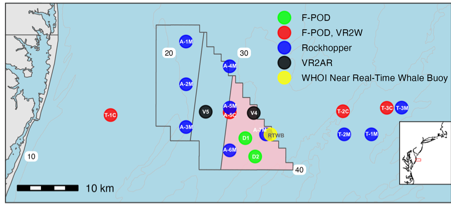
US Wind array off Ocean City, MD, Apr 2023 - present3
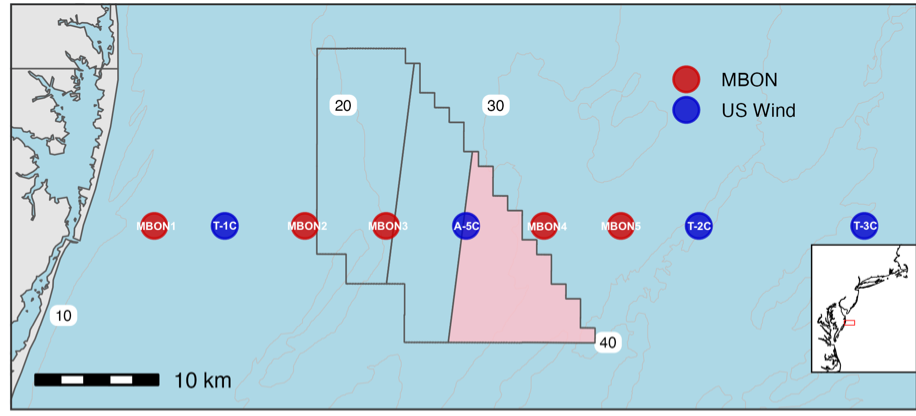
MBON array off Ocean City, MD, Nov 2024 - present
Footnotes
An industry change in schedule caused cessation of Rockhopper and US Wind array assets for the period 2024-2026. Maps display PAM and biotelemetry monitoring devices deployed within and surrounding the Maryland Lease Area (black outline, MARWIN region shaded pink). Monitoring with the WHOI Near Real-Time Whale Buoy spans 2021 to present.↩︎
An industry change in schedule caused cessation of Rockhopper and US Wind array assets for the period 2024-2026. Maps display PAM and biotelemetry monitoring devices deployed within and surrounding the Maryland Lease Area (black outline, MARWIN region shaded pink). Monitoring with the WHOI Near Real-Time Whale Buoy spans 2021 to present.↩︎
An industry change in schedule caused cessation of Rockhopper and US Wind array assets for the period 2024-2026. Maps display PAM and biotelemetry monitoring devices deployed within and surrounding the Maryland Lease Area (black outline, MARWIN region shaded pink). Monitoring with the WHOI Near Real-Time Whale Buoy spans 2021 to present.↩︎